Products
Industries
Resources
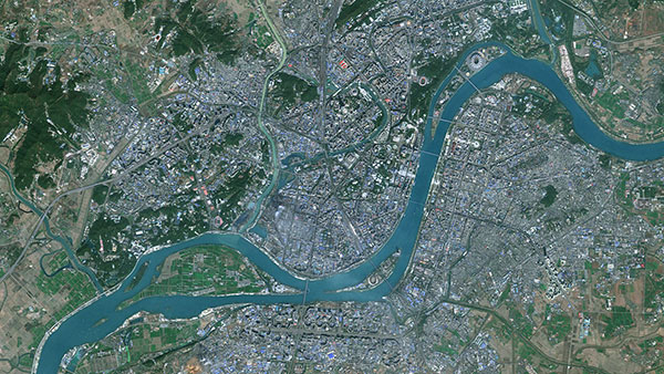
Experience clearer, more detailed views of France with our 5m satellite imagery. Explore now!

In many practical applications, insufficient spatial resolution of images poses a significant limitation, particularly when higher-resolution images are difficult to collect or too costly. This issue is prevalent in remote sensing, including with Sentinel-2 satellite images, which are freely available. They offer a high revisit frequency but are limited to a 10m ground sampling distance. However, AI and super-resolution algorithms can enhance this resolution. Although the resulting images do not match the quality of native high-resolution images, they offer a valuable result that balances cost and quality effectively.
At PlanetObserver, we are excited to introduce our newest product: PlanetSAT 5m imagery. This innovative product offers a 5-meter resolution, created by applying advanced AI techniques to our existing PlanetSAT 10m imagery.
Currently available for France, PlanetSAT 5m delivers more detailed and accurate images, making it a valuable tool for professionals in various fields.

PlanetSAT 5m improves upon our current 10m resolution global basemap, offering twice the detail. This enhancement allows for better visibility of finer details, which is crucial for urban planning, environmental monitoring, and resource management.
Using sophisticated AI upscaling algorithms and deep learning, we enhance the quality of Sentinel-2 based PlanetSAT 10m imagery. These algorithms reconstruct high-resolution details from lower resolution data, resulting in clearer and more detailed images. The enlarging process adds realism and sharpness to the imagery, making them suitable for a larger range of applications.
PlanetSAT 5m is currently available exclusively for France as a test phase. This ensures that projects within France benefit from the high-quality imagery offered by our new product. The 5-meter super resolution will then be expanded to other regions of the world, upon request.
We continue to provide 100% cloud-free coverage. PlanetSAT 10m basemap is annually updated with the best cloud-free images throughout different seasons to ensure accurate and consistent data.
At PlanetObserver, we strive to provide high-quality geospatial data to meet the diverse needs of our clients. PlanetSAT 5m combines advanced technology with practical usability, offering a product that can be integrated into various workflows. Our 5m imagery is available in formats like GeoTIFF, COG, and JPEG 2000, ensuring seamless integration into any existing systems. Whether you need comprehensive coverage for France or specific regional imagery, PlanetSAT 5m provides the flexibility and precision you require.

- Mapping and Visualization: With its enhanced resolution, PlanetSAT 5m is ideal for detailed mapping and visualization. It provides a clear and precise view, which is essential for urban planning, infrastructure development, and land mapping.
- Military Applications : 5-meter resolution imagery is valuable for military applications such as mission preparation systems, offering reliable geospatial data that enhances situational awareness and decision-making. This high-resolution imagery aids in strategic planning, detailed mission planning, managing ongoing missions, and improving the accuracy of visualization and navigation tools for military operations.
- Flight Simulation and Training: For flight simulation, high-resolution imagery is essential for creating realistic environments. PlanetSAT 5m provides the detail needed to enhance the realism and accuracy of flight simulation programs, making training and simulation exercises more effective.
To see the enhanced resolution and clarity of PlanetSAT 5m (in beta version), try our interactive viewer on our website. This tool allows you to explore any location within France at a 5-meter resolution, giving you a firsthand look at the quality of our new imagery.
Explore PlanetSAT 5m and see how it can benefit your projects.
Learn more about our latest offering on our website or contact our team for more information.