Products
Industries
Resources
PlanetObserver showcases its capabilities in Geospatial Data Sourcing.

In the demanding world of geospatial data production and satellite imagery processing, standing out requires not just expertise, but a deep commitment to customer needs and satisfaction. With over three decades of experience, PlanetObserver has a proven track record of commitment in this field.
In a series of 5 articles, we aim to provide insight into who we are and why we're a reliable choice for your geospatial data needs. We're delighted to share insights from Pierre Dubus, our Technical Director at PlanetObserver, who brings over twenty years of experience to our team and has contributed to the writing of this article. As our in-house satellite imagery specialist, Pierre has greatly contributed to the advancement of our capabilities in geospatial data processing.
Our first article will focus on geospatial data sourcing, a fundamental aspect of our service and production capabilities. At PlanetObserver, we specialize in acquiring various types of geospatial data, ranging from medium to very high-resolution imagery and elevation data.
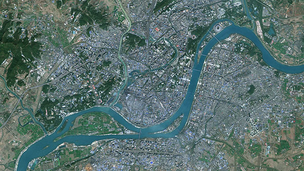
Our primary objective is focused on enhancing our global 10-meter imagery basemap, known as PlanetSAT. To achieve this goal, we exclusively utilize open imagery at 10-meter resolution sourced from Sentinel-2 cutting-edge satellites from the European Union’s Copernicus program. With both Sentinel-2 satellites having a 290 km swath, a significant improvement over the 185 km swath width of Landsat satellites, we benefit from enhanced coverage. Furthermore, the five-day revisit time offered by these satellites significantly increases the likelihood of obtaining cloud-free images. Capturing multi-spectral data across 13 bands, we selectively utilize the three-color bands—Red, Green, and Blue—to craft natural color mosaics for our PlanetSAT basemap.
Sentinel-2 imagery is sourced from different platforms, including PEPS, the operating platform for Sentinel products powered by the French Space Agency (CNES). Other alternatives include Sentinel Hub that gives the ability to automatically archive, process in real-time, and distribute remote sensing data and related Earth Observation products.
As an additional source, we may also use Landsat 8 imagery at 15-meter resolution, another advanced satellite managed by NASA and the United States Geological Survey (USGS). With a swath width of 185 km, Landsat 8 captures more than 700 scenes daily across 9 spectral bands. Once more, the three-color bands remain the primary focus in the majority of our customers' projects.
Landsat imagery has been historically made available from Earth Explorer, the geodata portal of the Geological Survey (USGS). This portal grants access to digital USGS data including satellite imagery, digital aerial photos, and map products.
All of these medium-resolution imagery sources are openly accessible as raw data, provided free-of-charge. However, transforming this raw data into comprehensive, ready-to-use products covering vast territories, even on a global scale, demands a high degree of expertise. This crucial aspect will be highlighted in our upcoming article showcasing PlanetObserver's capabilities.

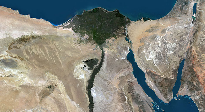
Furthermore, we serve as distributors of highly detailed commercial data from Maxar and Onyx Space, providing resolutions as fine as 30cm. Through European Space Imaging, the Munich-based European partner of Maxar, we access a full portfolio of satellite imagery at 30cm, 40cm and 50cm resolution. Besides, 15cm HD imagery processed from native 30cm imagery are also available on-demand for any project where improved visual experience is required.
Onyx Space offers an extensive portfolio of Earth observation satellites, providing resolutions of optical data ranging from 2m up to 30cm, with the additional capability of super resampling at 15cm from 30cm imagery. Such data facilitates precise analysis and informed decision-making.
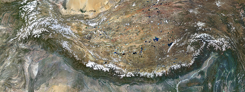
Within our offering, we also include 2.5-meter and 5-meter elevation data as Digital Surface Models (DSM) and Digital Terrain Models (DTM) sourced from NTT Data Japan. Those elevation data are processed from data acquired by the ALOS satellite from the Aerospace Exploration Agency (JAXA).
By working with multiple partners and suppliers, we guarantee our clients access to top-tier data, tailored to their individual and specialized needs.
When sourcing geospatial data, ensuring accuracy, consistency, and suitability for diverse projects is paramount. At PlanetObserver, meticulous attention is paid to a range of criteria to deliver optimal results.
In the upgrades and updates of our PlanetSAT 10-meter basemap, factors like cloud cover, snow cover, and seasonality are carefully considered to maintain uniformity in both color rendition and terrain depiction. Specifically, a preference for summer acquisition periods ensures a harmonized color palette throughout the entire mosaic of images, guaranteeing, for instance, that forests maintain a uniform shade. In the Northern Hemisphere, we prioritize acquisition during the months of June, July, and August, while in the Southern Hemisphere, our focus lies on December, January, and February, aligning with optimal conditions for imagery acquisition and color consistency.
When undertaking clients’ projects, we rigorously adhere to their specific technical specifications. Drawing from our extensive portfolio of geospatial data, we conduct a thorough search to identify and procure the most suitable datasets available. This comprehensive process ensures that we deliver tailored solutions precisely aligned with our clients’ unique requirements.
In conclusion, Part 1 of our exploration into PlanetObserver's capabilities has shed light on our expertise in geospatial data sourcing. Our proficiency is comprehensive, covering precise image selection tailored to specific criteria to guarantee optimal quality. Through selecting the finest imagery and elevation data, our commitment to quality ensures that clients receive top-tier solutions tailored to their needs.
Stay tuned for upcoming articles where we delve deeper into our technical skills and advancements in the field of geospatial technology.